 |
|
In 2012 various botanical surveys of Lea Marshes were compared. To view this comparison table click this link. | |||
| Walthamstow Marshes: Heritage |
WALTHAMSTOW MARSHES - OUR HERITAGE
In '45 there was rebellion in the land. Most of Scotland was under the rule of the Young Pretender, Bonnie Prince Charlie. His Highlanders had routed the Government troops under Sir John Cope on the battlefield of Prestonpans and marched down through England to reach Derby. Most of the English army was in Flanders, and in London there was panic; a run on the bank was only met by paying out in sixpences. A Government force encamped on Finchley Common to protect London.
In that year of 1745 John Rocque was completing his survey of the County of Middlesex. His map, carefully preserved in the Hackney Borough Archives, shows the villages of the Hackney area set amidst open countryside. By the village of Clapton the fields fell steeply to the clear-flowing Lea and across the river a wide open level stretched to the distant village of Walthamstow on gently rising ground.
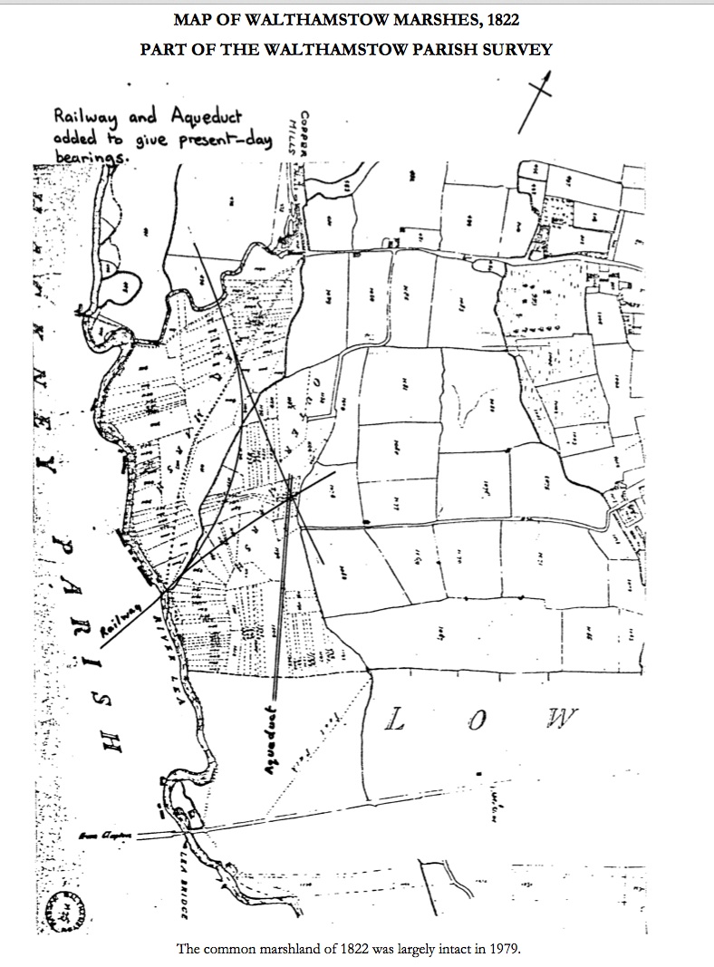
WALTHAMSTOW IN MEAD was John Rocque's name for this large flat expanse. The land was described as 'meadow, common marshland' in the analysis of the Walthamstow parish rate book of 1836. This common marshland meadow is shown on the map of 1822 (opposite), part of the Walthamstow parish survey of 1822, which is displayed in the Borough's delightful Vestry House Museum. A drainage channel divided the common marshland into two great meadows, the Inner Marsh and Outer Marsh, before entering the Lea where the railway now crosses the river. Drained marshland produced very good hay and two crops were harvested each year. What a sight the expanse of rich meadow must have been, a vast smooth green carpet - which the west wind could turn to a moving sea beating towards the far shore.
Then came the Industrial Revolution. Railway embankments swept majestically across the flat land breaking up the Outer Marsh into an assortment of shapes. The Inner Marsh held on to a good deal of its area and most of its river boundaries. The long towpath walk was unaffected, although the Diagonal Path that struck off towards Coppermill was swung round to its present line, and the local people went on using their traditional routes. The coming of the railway may have changed the Marshes, but it had not destroyed them. Indeed, the Inner Marsh was now protected by the long curve of the embankment from the outside world - the railway builders had paradoxically helped to preserve it against the coming tide of industrialisation.
We have an account, thanks to the Walthamstow Antiquarian Society's leaflet, of an historic event in the Summer of 1909. A.V. Roe's aeroplane flight on the Marshes was the first all British flight. His flimsy tri-plane, constructed in a workshop under the railway viaduct, can be seen on display in the Science Museum.
By 1935 the Marshes were officially described as public open space and that is how they are used today, with ownership vested in the Lee Valley Regional Park Authority.
Common marshland, public open space, the Marshes have withstood the test of time, surviving the coming of the railway and the tide of industrialisation. Now in this Summer of 1979 the Marshes face a different reality, the grim reality of this sentence of death by its new owners: "Walthamstow Marshes you are found designated as vacant land and shall be dug up and demineralised until you are destroyed."
But these Marshes are not vacant, unfilled, unoccupied, and we press for their reprieve.
Please write stating your objection to the destruction of the Marshes to:
Department of the Environment Room 12/06 Tollgate House Houlton Street Bristol BS2 9DJ
MAP OF WALTHAMSTOW MARSHES, 1822 PART OF THE WALTHAMSTOW PARISH SURVEY Created by John Coe

The common marshland of 1822 was largely intact in 1979. 
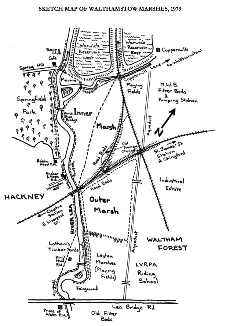
SKETCH MAP OF WALTHAMSTOW MARSHES, 1979 |