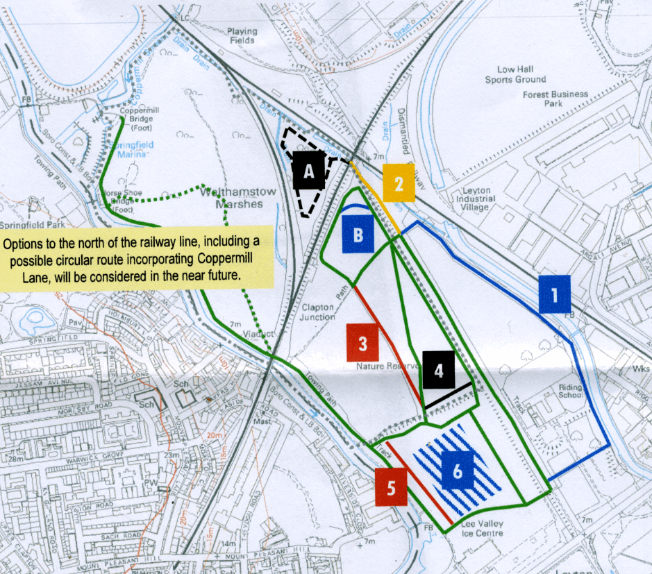
| This map was revealed at the user forum on February 24, 2010. To find the rather sketchy proposals, and some obvious responses, simply click the coloured square on the map. Recommendation six is the really shocking one. Most of the others are of little consequence: horses rarely use the marsh, LVRPA is simply providing subsidised stabling. |

|
| Revising the permissive bridleway network to reduce pressure on the SSSI
Rangers and riders met on 15 December 2009 to discuss options for equestrian access on the Walthamstow and Leyton Marshes to the south of the railway line. |
|
Recommendation 1: Permit use of path around perimeter of riding centre paddocks. This has the benefit of being outside the SSSI and typically experiences less traffic than other routes on the marshes. Some alterations to gates will be needed. |
| COMMENT: The reason this path is under-used (though far more people use it than there are ever horses on the entire marsh) is that it has been cut down to a sliver by the expansion of the paddock. If the horses were not there then it would be better used. Having said that, under the circumstances there is no real reason to object, though it is strange that the horses can not use the paddock! Basically what is going on here is a slow but purposeful land grab. Despite the fact that the horses make very little by way of contribution to the marshes (an economist would say they are being heavily subsidised) while £10m is paid by community charge payers each year, the horsey people have ambitions to take over. |
| Return to map |
|
|
Recommendation 2: Extend permissive route along aqueduct path north to the railway bridge. This has the benefit of being outside the SSSI, and could permit future access to the railway triangle (Area A) subject to Network Rail permission. |
| COMMENT: Nearly everyone, apart from the LVRPA, calls this the Sustrans route not the aqueduct path. In any case the triangle is owned by Hackney Council not Network Rail. Very strange! However, if it means allowing the horses to use the Sustrans route as far as the railway line, it seems perfectly sensible. |
| Return to map |
|
Recommendation 3: Permit use of path on south Walthamstow Marsh alongside cattle field fence. Although within the SSSI, this will relieve pressure on the existing routes on this marsh, and offer riders greater opportunities to avoid other users and hazards. Moreover, with greater choice of permitted bridleways, riders could be guided by rangers to select routes that take account of the changing conditions of the ground and vegetation, and minimise damage to the SSSI. |
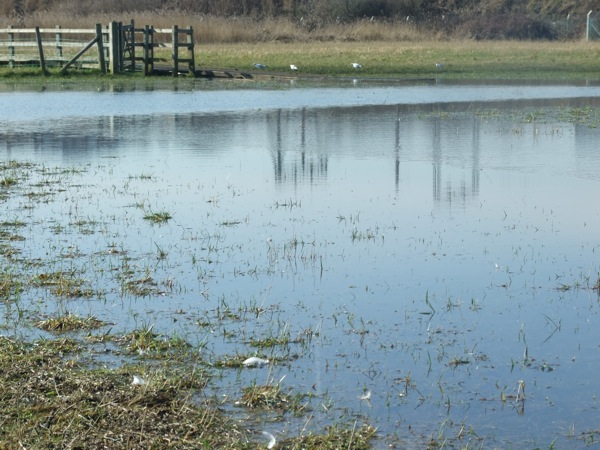
| See Walthamstow Marsh in flood March 2010. |  |
| COMMENT: It is encouraging to hear that the rangers are going to start guiding the riders. This path is frequently used by riders, at least as much as any path is used by them. However, this practice should come to an end, since the area at the end of the board walk (eccentrically marked on the map as the Clapton Junction Path, presumably because it is not in Clapton and there is no junction there!) has been too muddy to use for much of the winter. Horse trafic can only make things worse. There is, however, no reason why horses should not use this path in summer.
This is one of the few routes that is clearly coming under pressure (as evidence: the mud) and if pressure needs to be relieved, it needs to be relieved from here. |
| Return to map |
|
Recommendation 4: Permit use of path along tree line to south of Walthamstow Marsh. Although within the SSSI, this will reduce the need for riders to climb the bank in the southwest corner of Walthamstow Marsh onto the Leyton Marsh which can have poor visibility especially when the trees are in leaf and vegetation tall. Again riders could be guided by rangers and choose routes that take account of the changing conditions of the ground and vegetation. |
| COMMENT: This seems reasonable. It would be nice if the LVRPA would call a truce in the war it wages on local names and call Porter's Fields by the name locals use instead of Leyton Marsh. |
| Return to map |
|
Recommendation 5: Mow and permit use of a new path parallel to Sandy Lane on Leyton Marsh. This has the benefit of offering separation of horses from traffic which, given the quality of the verge, is not possible currently on Sandy Lane. |
| COMMENT: This path already exists and is commonly used by riders. LVPRA appears to be trying to change the rules to legalise what the horsey people do. Horses rarely use the marshes since the riders seem to regard the riding centre as cheap stabling facilities. Although by rural standards so called livery (basically bed and board for a horse) is quite expensive at Lea Marsh, there are very few facilities for horses in the London area. As a consequence there has been demand to increase stabling facilites at Lea Marsh, since a commercial orgnistion probably could not compete with LVRPA's charge of about £8k a year.
On the rare occasions when horses do actually use the marsh there is little problem with the humans on the paths. Most people like to see the horses. The conflict is with the dogs. Having a legalised path is hardly likely to reduce the chance of conflict with dogs. Quite why councils across London are paying for this is beyond understanding. |
| Return to map |
|
|
Issue B: Riders and other users currently 'cut the corner' in the northerly point of the south Walthamstow Marsh because of the overgrown vegetation and limited path width in an area owned by Network Rail. Once vegetation has been cleared in the area, riders will be able to keep to the marked route. |
| COMMENT: Riders very rarely use this area, though that applies to most of the marsh. The vegetation is not really overgrown but cutting it back probably won't do any harm. However, see proposal made by architectural consultants for this area. |
| Return to map |
|
Recommendation 6: Permit riding and schooling of horses during quiet periods on the interior of Leyton Marsh, which has the benefit of being outside the SSSI.
|
| Return to map |
|
Recommendation A: There is no recommendation A.
|
| Return to map |
|