| | |
| | |
| | |
From http//www.wargrave.net/history/history.html
Wargrave Local History Society
A Potted History of the Village
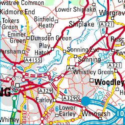
Wargrave is a Thames-side village, and the parish is essentially rural in character. The western boundary of the parish is formed by the rivers Loddon and Thames. The land rises from the village itself to other communities in the parish on the tree-clad hills to the north and east, with Bowsey Hill some 345 feet higher than the village centre. A large part of the area is wooded, particularly with oak, beech and ash. A number of fields lie on or near the flood plain, whilst others are on the open hilltop towards the north of the parish, around Crazies Hill. Many of the ancient field boundaries are marked by hedgerows, adding to the variety of ecological habitats. The main rock underlying this area is chalk, evidence of which can be seen in several chalkpits in the area. There are also outcrops of clay, sand and flints overlying the chalk. Several streams that begin on the clay on Bowsey Hill later disappear when their course reaches the chalk. Deposits of gravel exist to the south of the village, near the Loddon, and alluvium deposits exist in the river flood plain.
Wargrave has a long history. The first documentary evidence occurs in a charter dated 1061 of Edward the Confessor, which mentions "a late 10th century grant to the Old Minster of Winchester" (i.e. the Bishop of Winchester). Although the authenticity of this document is questionable, the village certainly existed by that time. The Domesday survey, completed in 1086 refers to Wargrave, with the Manor of Wargrave belonging to the King. This states that before 1066 it had belonged to Queen Edith, the wife of Edward the Confessor. At the time of Domesday, the Wargrave's 5000 acres had a population of about 250 people. The land was worked by 29 ploughs, the mill rendered 9/2d, and their were 3 fisheries on the river (eel traps at weirs, producing about 3000 eels a year). Valued at 27/6/8d, Wargrave was one of the richest and most populous places in East Berkshire. At that time, Windsor Forest came as far as the River Thames at Wargrave. The weirs on the river being surrounded by groves (areas of woodland) is most likely how the village got its name ( which is written Weregreave on early documents).
The earliest site of the village was probably the area of Mill Green, or the land between the River Loddon and Wargrave station, both showing signs of early settlement. The riverside site would have been liable to flooding, and it seems most likely that the village referred to in the 11th Century was near the Church, with a continuation of Church Street being one of the main streets. By 1199, the Manor belonged to the Bishop of Winchester again (and remained so until the 16th Century). The bishop had the land cleared, fenced and ditched, and in 1218 was granted the right to hold a market at Wargrave. By 1225, Wargrave was recorded as being a borough, with its own bailiffs and jurors. It seems that a new village was developed, therefore, in the 13th Century, and most of the houses around Mill Green were abandoned. Whether this was due to problems of flooding, an outbreak of plague, or a desire to be around the Henley road, or some other reason is not recorded. A survey of 1607 states that the manor house was near the Church, where there was "an ancient house with many necessary rooms such as hall, parlour etc" A 1634 glebe terrier adds that land round the Church was "tythe or gardenage ... where anciently houses or orchards have stood, but converted to pasturage or tillage."
The 13th Century village was laid out as burgage plots along the High Street, with back lanes on both sides (Ferry Lane and Backsideans), Timber Cottage being a building surviving from the 14th Century. The village settlement developed along the High Street, in both directions, in the 17th and 18th Centuries, dominated to the north by the Georgian mansion of Wargrave Hill,Ā (now known as Wargrave Manor). By the early 19th Century, the village had begun to spread to the east, so that by 1837 there were houses up the hill towards the workhouse (the present site of Elizabeth Court). The rest of Victoria Road dates from the second half of the century, with some later infill. The Highfield Park area is post-war housing, the roadway having been originally laid for a wartime army camp. Former farmland to the north of Victoria Road was developed as housing in the late 1960's and 1970's. The area towards the River Loddon was built up in the early part of this century. Many of the dwellings around the Loddon itself stem from 1930's development - often initially as houseboats.
The Church is first mentioned in a document of 1121, from which it is clear it already existed. The present tower dates from 1635, whilst the building was altered in 1817 and 1849. Apart from the tower and north wall, however, most of the present building dates from the rebuilding following a fire in 1914.
For much of this period, the farmhouses were situated in the centre of the village. Hamilton House, in the High Street, and Ouseleys, in School Lane, are among those that remain. The fields around the village were largely farmed on the strip system. The enclosure of the fields was, largely, carried out in 1818, when sections were parcelled together for each farmer. The fields around Willow Lane were chiefly used as summer meadows for grazing cattle. An indication of the variety of crops produced is given by the produce on which tithes were levied. In 1634 these were paid on wood for poles, faggots and walking sticks, osiers, grass on eyots, lambs, calves, colts, pigs, cygnets, honey, wax, ale, pigeons, soft fruit, poultry (geese and turkey), and garden produce (which included roots, seeds, onions, garlic, flax and hemp, apples and pears).
The foundation of the village schools dates back over 200 years, having already been in existence when Robert Piggott wrote his will in 1796. The Piggotts were a long-standing Wargrave family and Robert established two schools, one for boys and the other for girls, in the High Street, and his sister, Anne, left a further large sum of money in her will for the schools when she died in 1827. The three Wargrave schools are Church of England foundations - and recall the Piggott name in their title, all being descended from the original foundation.
Most of the development in Wargrave has left the medieval village essentially untouched. Although a number of buildings have cellars - often of chalk, a local material - which have destroyed or damaged the earlier remains, Wargrave has one of the best preserved archaeological records in Berkshire.
By Peter Delaney.Ā Wargave Local History Society 1998
Other towns & villages
| Aldbourne, Wiltshire |
| Brind, Yorkshire |
| Catmore, Berkshire |
| Chieveley, Berkshire |
| Fawley, Berkshire |
| Highworth, Wiltshire |
| Kington St. Michael, Wiltshire |
| Liddington, Wiltshire |
| Wargrave |